Every day, inside warehouses, hospitals, airports, and office towers, thousands of people search for things they cannot see. A nurse hunts for a missing IV pump. A logistics coordinator cannot locate a pallet. A security guard needs to find a colleague in distress. A visitor stands in a terminal entrance, looking for Gate 47.
The common thread across all of these problems is visibility. Or more precisely, the lack of it. Real-Time Location Systems (RTLS) were built to solve exactly this — to give facilities a continuous, accurate, live picture of where every tagged person, asset, or piece of equipment is, at any moment, indoors.
This guide explains what RTLS is, how it works at a technical level, what makes modern BLE 5.1-based systems fundamentally different from earlier generations, and how organizations across industries are using location intelligence to operate more safely and efficiently.
- RTLS is a technology that provides continuous, real-time location data for people and assets inside a facility — where GPS cannot reach.
- Modern RTLS uses BLE 5.1 with advanced machine learning algorithms — achieving room-level and sub-room accuracy on standard off-the-shelf hardware, with no AoA infrastructure required.
- RTLS 3.0 marks the shift from “tracking dots on a map” to intelligent, AI-driven workflow orchestration.
- RTLS serves healthcare, airports, enterprise, manufacturing, retail, education, and industrial sectors — any environment where indoor location visibility has operational value.
- The business case is consistent across verticals: reduce search time, prevent loss, automate workflows, and improve safety.
What Is RTLS?
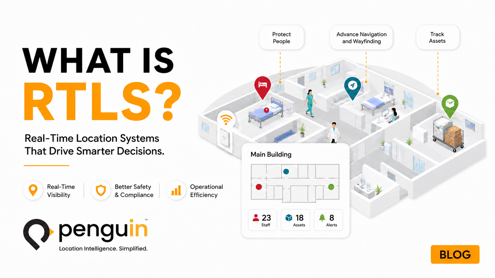
RTLS stands for Real-Time Location System. It is a technology framework that continuously determines and communicates the physical location of tagged objects or people inside an enclosed space — typically a building, campus, or industrial facility — and makes that location data available to software systems, dashboards, and automated workflows.
The distinction from GPS is fundamental. GPS relies on satellite signals that cannot penetrate building structures reliably. Inside a hospital, a warehouse, an airport terminal, or a corporate campus, GPS delivers insufficient accuracy or no signal at all. RTLS fills this gap by using indoor radio infrastructure — readers installed throughout the facility — to triangulate or calculate the position of small wireless tags attached to people or assets.
The result is a live, continuously updated map of every tagged item across the facility. A staff member can open a dashboard or mobile app, search for a specific asset by category or ID, and see its current location down to the room or bay — without moving from their workstation.
Modern RTLS platforms go further than simple location. They integrate with existing enterprise systems — EHR, CMMS, nurse call, access control, production scheduling — and use location data as the trigger for automated workflows: redistributing assets before shortages occur, alerting security when a duress button is pressed, routing visitors through a complex campus, or flagging workflow bottlenecks in real time.
How RTLS Works: The Three-Layer Architecture
Regardless of the specific technology, every RTLS system operates on the same three-layer architecture: tags that broadcast signals, readers that receive those signals, and software that translates signal data into actionable location information.
Small, wireless devices attached to assets, worn by staff, or embedded in wristbands. Tags broadcast a unique identifier signal at regular intervals. Modern BLE tags are coin-sized, battery-powered for 2 to 5 years, and require no external power connection.
Fixed receivers installed throughout the facility — on walls, ceilings, or existing network hardware. In BLE 5.1 systems, many existing enterprise Wi-Fi access points (Cisco Meraki, Juniper Mist, Aruba) serve as readers, minimizing new hardware requirements.
The location engine processes signals from multiple readers to calculate each tag’s position and surfaces this data through dashboards, APIs, mobile apps, and automated workflow triggers — giving staff and integrated systems access to live location intelligence.
How Location Is Calculated
The core challenge in indoor positioning is converting radio signal data into an accurate physical location. Different RTLS technologies approach this differently — and the method used determines accuracy, cost, and reliability.
Older systems relied on signal strength estimation — the stronger the signal from a tag, the closer it must be to the reader. The fundamental problem is multipath interference — radio signals bounce off walls, metal equipment, floors, and ceilings. Inside a complex building, a tag in one room can produce a signal pattern that appears to come from an adjacent room. Signal strength-based systems in real environments are notoriously inconsistent.
Penguin’s BLE 5.1 platform solves this through advanced machine learning — processing the full signal space simultaneously to separate direct signals from multipath reflections. Critically, this delivers consistent room-level and sub-room accuracy without AoA infrastructure, without proprietary antennas, and without infrared or ultrasound supplementation. The result is reliable positioning on standard off-the-shelf hardware even in environments dense with signal reflectors.
The Evolution of RTLS: From 1.0 to 3.0
RTLS technology has passed through three distinct generations, each defined by the underlying technology and what it enabled operationally.
1.0
Infrared, Ultrasound & Proprietary RFID (1990s – 2010s)
First-generation RTLS used infrared emitters, ultrasound readers, or proprietary active RFID. These systems required expensive, purpose-built infrastructure — dedicated readers every 3 to 5 meters, proprietary tags that only worked with that vendor’s hardware, and complex installation projects. Accuracy was limited to room-level, battery replacement for large fleets was a significant burden, total cost of ownership was high, and vendor lock-in was total.
2.0
Wi-Fi Signal Strength & Early BLE (2010s – early 2020s)
The second generation leveraged existing Wi-Fi infrastructure and early Bluetooth Low Energy, reducing deployment costs — but the underlying location method remained signal strength-based. Zone-level accuracy was achievable; room-level was inconsistent. Vendors charged significant licensing fees for location data. AI and workflow integration were minimal. “Connected tracking” was the defining phrase: more data, but not yet intelligent.
3.0
BLE 5.1 + AI + Workflow Orchestration (2024 – present)
RTLS 3.0 is the current generation — and it represents a fundamentally different category. The technology shift is BLE 5.1 with AI-powered machine learning algorithms: room-level and sub-room accuracy on standard off-the-shelf hardware — without AoA infrastructure, proprietary antennas, or vendor lock-in. The operational shift is from “dots on a map” to intelligent orchestration — location data feeding AI models that predict shortages, detect burnout risk, automate maintenance scheduling, route visitors, and trigger emergency protocols. Penguin’s RTLS 3.0 platform defines this transition as the move from “connected tracking” to “intelligent, secure orchestration.”
Why BLE 5.1 Is the Foundation of Modern RTLS
Bluetooth Low Energy 5.1 is the radio standard that defines RTLS 3.0. Understanding why requires a brief technical comparison with what came before.
Earlier BLE versions and Wi-Fi RTLS relied on signal strength estimation as a proxy for distance. In a controlled environment with clear lines of sight, this works reasonably well. In any real facility — with metal shelving, elevator shafts, concrete walls, RF-congested air, and thousands of reflective surfaces — signal strength-based positioning produces location estimates that are inconsistent enough to undermine operational reliability.
BLE 5.1 introduced significant hardware advances that enable far more sophisticated location algorithms. Penguin applies advanced machine learning algorithms to BLE 5.1 hardware — processing the full signal space simultaneously to separate direct signals from multipath reflections. This delivers reliable room-level and sub-room accuracy even in environments with heavy RF interference, without requiring AoA infrastructure or proprietary antennas.
Three practical consequences flow from this:
- No proprietary hardware required. BLE 5.1 is an open standard. Many enterprise Wi-Fi access points already include BLE 5.1 radios. Where supplemental readers are needed, standard adhesive-mounted BLE anchors cover the gap — no cabling, no construction.
- Dramatically lower cost. Infrastructure that was previously purpose-built and proprietary is now commodity hardware. Tag costs have dropped by an order of magnitude from first-generation RTLS.
- No vendor lock-in. Open standards mean the hardware layer is interchangeable. The value is in the algorithm and the platform — not the proprietary antenna.
The RTLS Market: Scale and Growth Trajectory
RTLS has moved well past early adopter status. Multiple independent research firms track the market and all point in the same direction — rapid, sustained growth driven by healthcare adoption, manufacturing automation, and the broader shift toward real-time operational intelligence.
Sources: Mordor Intelligence RTLS Market Report · MarketsandMarkets RTLS Market Report
North America leads global adoption, supported by advanced digital healthcare infrastructure and strong regulatory emphasis on workplace safety. Healthcare providers in the region have been the primary demand driver — using RTLS to improve care coordination, equipment utilization, and staff safety compliance simultaneously.
How Indoor Positioning Is Calculated: RSSI, AoA, TDoA — and Why ML Changes the Equation
Every RTLS system must solve the same fundamental problem: converting radio signal data from multiple readers into a physical location. The industry has developed three primary methods for doing this — each representing a different trade-off between accuracy, infrastructure cost, and reliability in real environments.
RSSI — Received Signal Strength Indicator
RSSI is the most widely deployed positioning method in first and second-generation RTLS systems. The principle is simple: the stronger the signal received from a tag, the closer the tag must be to the reader. By comparing signal strength across multiple readers, the system estimates proximity and infers location.
The core problem is multipath interference. Inside any real building, radio signals reflect off walls, metal equipment, glass, and concrete. A tag in one room can produce a signal pattern that appears to originate from an adjacent corridor. RSSI-based positioning degrades significantly in complex RF environments — which covers every hospital, warehouse, and manufacturing plant.
AoA — Angle of Arrival
AoA improves on RSSI by measuring the direction a tag’s signal arrives at the reader rather than just its strength. Readers equipped with multi-antenna arrays calculate the incoming signal angle, and combining angle measurements from multiple readers triangulates the tag’s position with greater accuracy.
The trade-off is infrastructure. AoA requires specialized reader hardware with multi-antenna arrays — it cannot run on standard Wi-Fi access points or basic BLE readers. Deployments require purpose-built infrastructure investment, limiting cost-effective coverage. AoA also remains sensitive to multipath in environments with dense metal or complex geometry.
TDoA — Time Difference of Arrival
TDoA calculates position by measuring the difference in time it takes a tag’s signal to arrive at multiple synchronized readers. Because radio signals travel at the speed of light, nanosecond differences in arrival time correspond to measurable distance differences. TDoA is the positioning method behind UWB systems and can achieve centimeter-level accuracy.
The cost is significant. TDoA requires precise clock synchronization across all readers in the network — a technically demanding requirement that drives infrastructure cost and complexity. Maintaining synchronization across hundreds of readers in a large facility is an ongoing operational challenge. TDoA is the right choice where centimeter precision is genuinely required; for room-level use cases it represents substantial over-engineering.
Penguin’s ML Approach: A Different Architecture
Penguin’s platform does not rely on RSSI estimation, AoA antenna arrays, or TDoA synchronization infrastructure. Instead, it applies advanced machine learning to the full BLE 5.1 signal space — processing the complete signal environment simultaneously to separate direct-path signals from multipath reflections.
The result is room-level and sub-room accuracy on standard off-the-shelf BLE 5.1 hardware and existing enterprise Wi-Fi access points — in real hospital environments with heavy RF interference — without proprietary antennas, clock synchronization, or AoA hardware. The accuracy advantage typically associated with more expensive positioning methods is achieved through algorithmic intelligence applied to commodity hardware. That is what drives the total cost of ownership difference between RTLS 3.0 and legacy systems. For a technical deep-dive, see Penguin’s BLE 5.1 + Advanced Location Algorithms white paper.
RTLS Technology Comparison: BLE 5.1, UWB, Wi-Fi RTT, Active RFID, and Infrared
Each RTLS technology reflects a different set of trade-offs between accuracy, infrastructure cost, deployment complexity, and operational fit. Understanding the full landscape is essential to selecting the right system for a given environment and use case.
| Technology | Typical Accuracy | Infrastructure Required | Relative Cost | Best Fit |
|---|---|---|---|---|
| BLE 5.1 + ML | Room-level to sub-room (1–3m) | Standard BLE anchors; leverages existing enterprise Wi-Fi APs | Low–Medium | Healthcare, enterprise, senior care, manufacturing — any environment where room-level accuracy delivers full operational value |
| UWB | Centimeter-level (10–30cm) | Dedicated UWB anchor network with clock synchronization; cannot leverage existing Wi-Fi APs | High | Surgical instrument tracking, robotics, quality inspection — use cases where centimeter precision justifies significant infrastructure investment. UWB projected at 29.9% CAGR through 2030 as precision manufacturing and smartphone integration drive adoption. |
| Wi-Fi RTT | 1–3 meters (zone to room-level) | Existing Wi-Fi infrastructure (802.11mc/az compatible APs required) | Low | Corporate campuses and office environments with compatible AP infrastructure; limited healthcare adoption due to RF congestion sensitivity and AP compatibility requirements |
| Active RFID | Zone-level (choke-point detection) | Proprietary readers at doorways and corridors; dedicated frequency band; cannot track between read points | Medium | Building egress monitoring and high-value asset perimeter control — not suited to continuous real-time tracking across a facility |
| Infrared (IR) | Room-level | Purpose-built IR sensors requiring line-of-sight ceiling installation in every room | High | Legacy healthcare RTLS from the RTLS 1.0 era; rarely specified in new deployments due to installation cost, line-of-sight constraints, and proprietary lock-in |
The right technology depends on what accuracy a use case genuinely requires. UWB is correct where centimeter precision matters operationally. For the broad range of healthcare, enterprise, and industrial applications where room-level accuracy delivers full value, BLE 5.1 with advanced machine learning achieves equivalent outcomes at a fraction of the infrastructure cost — without proprietary hardware, antenna arrays, or vendor lock-in.
RTLS Accuracy Levels: What Each Means in Practice
| Accuracy Level | What It Detects | Typical Use Cases | Infrastructure Required |
|---|---|---|---|
| Zone / Floor | Which building, floor, or wing an asset is on | Theft prevention, egress alerts, building-level inventory | Minimal — one reader per floor or zone |
| Room Level | Which specific room or bay an asset or person is in | Asset retrieval, staff locating, patient flow, maintenance scheduling | Moderate — readers positioned to cover each room |
| Sub-Room / Bay | Which bay, shelf, or bed within a room | ICU patient association, decontamination verification, high-density storage | Higher density — additional readers in specific zones |
| Sub-Meter | Centimeter-to-meter precision within a space | Surgical instrument tracking, robotics, quality inspection points | Dense reader arrays; typically deployed in defined zones only |
The right accuracy level depends on the use case. Most operational applications — asset retrieval, workflow tracking, staff safety, maintenance scheduling — are fully served by room-level accuracy. Sub-room and sub-meter precision are additive layers deployed selectively in high-value zones where the operational benefit justifies the additional infrastructure density.
RTLS Across Industries: Eight Verticals, One Platform
RTLS is not a sector-specific technology. Any environment where people or assets move through complex indoor spaces — and where that movement has operational, safety, or financial consequences — is a candidate for location intelligence.
The most mature RTLS vertical. Use cases span asset tracking (IV pumps, infusion equipment, wheelchairs), staff duress and panic alerting, patient flow management, infant protection, wander prevention, hand hygiene compliance, and nurse call automation. Hospitals overpurchase mobile equipment by 15–20% on average due to poor visibility. See healthcare RTLS →
Airports deploy RTLS for passenger wayfinding through complex terminal layouts and asset tracking for ground support equipment, baggage carts, and maintenance tools. Travelers with mobility challenges benefit from turn-by-turn indoor navigation from the parking garage to the gate. See airport solutions →
Enterprise RTLS applications include space utilization analytics, hot-desk management, workforce safety for employees in isolated areas, visitor management, and automated attendance tracking. For multi-building campuses, RTLS provides the indoor navigation layer that GPS cannot. See enterprise solutions →
Manufacturing and industrial facilities use RTLS for tool and equipment tracking, work-in-progress monitoring across production stages, quality inspection point verification, and worker safety in high-risk environments. In oil, gas, and mining operations, personal duress systems enable lone workers to trigger emergency alerts with precise location data. See industry solutions →
Retail RTLS applications include indoor navigation for shoppers in large-format stores, staff locating for customer service optimization, asset tracking for high-value merchandise, and operational analytics on customer flow patterns. Location data reveals which zones attract dwell time and which are bypassed.
Educational campuses use RTLS for campus-wide wayfinding, asset tracking across labs and departments, automated attendance verification, and security applications. The wayfinding case is especially strong during orientation and examinations when thousands navigate unfamiliar multi-building layouts simultaneously. See education solutions →
Senior care facilities use RTLS for resident wander prevention — monitoring residents at risk of elopement and triggering alerts when they approach exit zones. Staff duress systems protect caregivers in isolated areas. Location data also supports family communication, staff accountability, and regulatory compliance documentation.
Warehouses deploy RTLS to track forklifts, picking equipment, and inventory pallets across large floor plans. Workflow analytics reveal bottlenecks in the pick-and-pack process. Safety applications include proximity alerts when personnel are near moving vehicles and duress systems for workers in isolated sections of large facilities.
Core RTLS Use Cases Across All Verticals
While each vertical has specific applications, six use case categories appear consistently across industries — and represent the clearest, most measurable operational value from RTLS deployment.
Asset and Equipment Tracking
The most widely deployed RTLS use case. Any organization that owns mobile equipment faces the same problem: equipment moves, and without visibility, it disappears. RTLS asset tracking delivers a continuously updated inventory of where every tagged item is, enabling staff to retrieve assets in seconds rather than minutes. At scale, this reduces over-purchasing, cuts rental dependency, improves maintenance compliance, and recaptures thousands of hours of productive staff time annually. Hospitals consistently report measurable ROI within the first year of deployment.
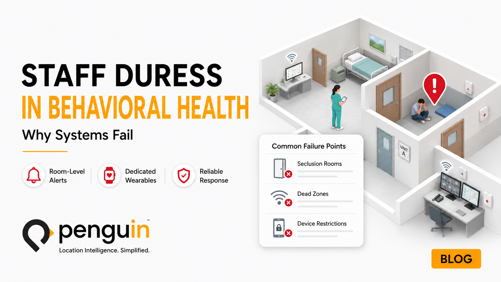
Staff Safety and Duress Alerting
Workers in isolated, high-risk, or confrontational environments carry wearable RTLS tags equipped with a duress button. When pressed, the system immediately alerts security with the worker’s precise room-level location. PenSafe™ protects nurses from workplace violence in healthcare and lone workers in remote areas of industrial facilities. Response time drops from minutes to seconds when security knows exactly where to go.
Indoor Navigation and Wayfinding
GPS-dependent mapping fails indoors. PenNav™ provides the positioning layer for indoor navigation apps that guide visitors, patients, employees, and customers through complex multi-floor, multi-building environments with turn-by-turn accuracy. The same infrastructure that tracks assets powers the visitor’s navigation app.
Workflow and Throughput Analytics
Location data is time-stamped. Aggregated across hundreds of interactions per day, it reveals where time is being lost, where assets accumulate, where people wait, and where processes diverge from the intended flow. Learn more about RTLS workflow analytics. This transforms RTLS from a real-time tracking tool into a retrospective analytics engine — enabling process improvement decisions grounded in actual movement data.
Automated Attendance and Access
RTLS can verify presence automatically — eliminating manual check-in, time card disputes, and compliance documentation for staff in regulated environments. Zone-level presence detection confirms that a worker arrived at a specific location at a recorded time, without requiring badge swipes or biometric interactions.
Preventive Maintenance Integration
When RTLS integrates with a CMMS, maintenance scheduling becomes location-aware. When an asset is due for service, the CMMS queries the RTLS for its current location. The technician walks directly to it. Usage-based maintenance triggers replace calendar-based schedules — assets that are heavily used are serviced more frequently, while lightly used devices are not pulled unnecessarily.
What RTLS 3.0 Changes
The defining characteristic of RTLS 3.0 is the integration of AI into the location layer. Previous generations delivered location data. RTLS 3.0 acts on it.
In practical terms, this means RTLS is no longer a passive reporting system. It is an active orchestration layer. The platform does not simply show that an asset is in Room 412 — it detects that Room 412 has had zero IV pump availability for 20 minutes, that the neighboring unit has three idle pumps, and triggers an automated redistribution alert before a shortage affects patient care.
Penguin’s RTLS 3.0 platform represents this shift explicitly. The company’s CEO Mohammed Smadi defines it directly: “What organizations need now is intelligent operations, not just dots on a map.” Location data without intelligence is monitoring. Location data with intelligence is operations. Penguin’s AI + Location Intelligence white paper covers how hospitals are making this transition in practice.
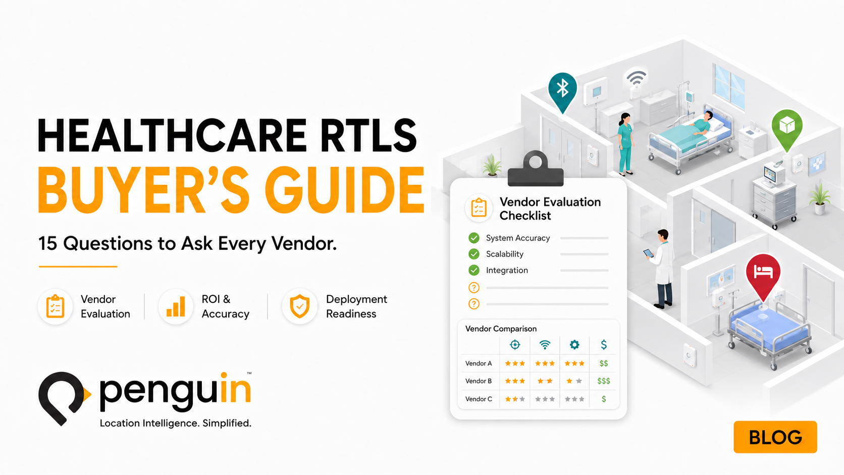
How to Evaluate an RTLS System: Five Questions
1. What is the location method?
Signal strength-based systems are cheaper to deploy but produce inconsistent room-level accuracy in real environments. BLE 5.1 with AI-powered machine learning delivers reliable room-level and sub-room accuracy on standard hardware — without AoA infrastructure. Ask specifically: how does the system handle multipath interference? Can it demonstrate accuracy in a facility similar to yours without proprietary infrastructure?
2. Is the hardware open or proprietary?
Proprietary RTLS hardware creates vendor lock-in — you cannot change platforms without replacing your infrastructure. Open-standard BLE 5.1 hardware is interchangeable. The value should be in the software and algorithms, not the antenna. Factor total cost of ownership over a 7 to 10 year horizon when comparing options.
3. What integrations does it support natively?
An RTLS platform that cannot integrate with your EHR, CMMS, nurse call, or access control system delivers isolated location data. The operational value multiplies when location triggers are connected to the systems your staff already use. Evaluate integration depth, not just integration capability.
4. What is the total cost of ownership?
Tag cost, reader cost, installation cost, software licensing, annual maintenance, and battery replacement costs must all be evaluated over the full deployment lifetime — not just the initial hardware quote. BLE 5.1 systems with commodity hardware and long-life tags reduce lifetime TCO significantly versus first-generation proprietary systems.
5. Does the platform include AI-driven analytics?
Live location tracking is table stakes. The differentiating value is predictive analytics, workflow automation, and actionable intelligence derived from location data. Ask whether the platform can identify patterns, generate alerts before problems occur, and integrate location data with operational decision-making — or whether it only reports where things are after the fact. Penguin’s RTLS in Healthcare white paper covers the full range of AI and ML trends reshaping what location platforms can do.
Frequently Asked Questions About RTLS
See What RTLS 3.0 Can Do in Your Facility
Penguin’s BLE 5.1 platform delivers room-level accuracy, AI-powered analytics, and rapid deployment — without proprietary hardware or vendor lock-in. Talk to our team about your environment.
Reach out today
Penguin Location Services delivers hospital asset tracking through PenTrack, built on BLE 5.1 technology with patented algorithms for room-level and sub-room accuracy. PenTrack runs on the same sensor infrastructure as PenSafe staff safety and patient monitoring applications — one deployment, multiple use cases. To learn more or request a demo, visit penguinin.com/pentrack or explore our full asset tracking solutions.